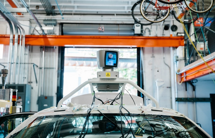
LiDARcan be defined as a remote detection and ranging technique that emits infrared light pulses instead of radio waves. The technique then measures how long the light pulses take to come back after hitting surrounding objects. The time between the output laser pulse and the reflected pulse permits the LiDAR sensor to calculate the distance to each object accurately. The calculation uses the speed of light.
The LiDARsensor captures millions of these precise distance measurements every second. This mapping of the environment gives vital information related to the shape, position, and behavior of each object.
LiDAR Sensor for Automotive Applications
Vehicles of all types use LiDAR to determine which hindrances are nearby and how far they are. LiDAR components offer 3D maps that are used to identify and position objects and detect what these objects are.LiDAR also uncovers insights that help a car’s computer system to predict how these objects will behave. As a result, the vehicle’s driving is adjusted accordingly.
Vehicles that are semi or fully autonomous use a combination of sensor technologies. This includes Radar. Radar provides constant distance and velocity measurements. Radar also provides an all-weather performance.
However, Radar’s resolution is low, and it struggles with the mapping of more precise details at longer ranges. Camera vision is another technology commonly used in automotive and mobility applications. The camera vision offers high-resolution information in 2D. However, it is overly dependent on powerful Artificial Intelligence and corresponding software to translate captured data into 3D readings.
Again, camera vision is greatly impacted by environmental and lighting conditions. LiDAR, on the other hand, offers precise 3D measurement data when it comes to short and long ranges. This is even in harsh weather and lighting conditions. This is why this technology is combined with other sensory data to offer a more reliable illustration of both the motionless and moving objects in the car’s environment.
As a result, LiDAR is theperfect solution for enhancing hindrance detection and avoidance. This enhances the safe navigation of cars through varying environments.
LiDAR Sensor Applications
There are multiple applications that use LiDAR to conduct analysis and disseminate data. They include:
- Climate change- scientists use LiDAR to study and track changes occurring in the atmosphere. LiDAR is also used to track patterns in changes to forested areas. In addition, the LiDAR sensor is used to calculate changes in glaciers as time goes by.
- Land management- organizations can monitor land resources in realtime. This enhances faster and more effective mapping compared to aerial surveys. LiDAR can be used in emergency response, location-based investigations, disaster evaluation, and early warning systems.
- Renewable Energy- LiDAR can be used to identify basic requirements for collecting solar energy. LiDAR can also be used to calculate direction and wind speed. This allows people who operate wind farms to build and place turbines.
- Land mapping- LiDAR is used to create accurate maps for the shoreline and digital elevation models for geographic information systems. LiDAR is also used in assisting with emergency response missions.
- Agriculture- LiDAR is used in the agricultural field to indicate areas that have optimal sunshine for more efficient growing. LiDAR is also used in identifying crops that need water or fertilizer as its data can train machine learning systems.
Benefits of the LiDAR Sensor
- High Resolution and Accuracy- the LiDAR sensor generates instant and massive amounts of measurements. In addition, the technology can be accurate up to a centimeter.
- 3D Mapping- data provided by LiDAR can be easily converted into 3D mapsto interpret the surrounding environment.
- Low light performance- since LiDAR is not affected by ambient light changes, it performs very well in low-light conditions.
- Speed- LiDAR provides direct distant measurements that don’t need to be decoded or interpreted. This enhances prompt performance, and it also minimizes processing requirements.
- The surface data in LiDAR has a higher sample density. This density enhances the results for certain applications
- LiDAR can allow you to collect elevation data in a dense forest. Normal photography fails in such environments because the accurate terrain surface cannot be seen clearly due to the dense canopy cover.
- You can integrate LiDAR with other data sources.
- Compared to other techniques, LiDAR uses an active illumination sensor,and it can be collected during the day or night.
There are no geometric distortions like those in Radarin LiDAR.


